Project Summary
The Wendling Beck Project (WBP) is a collaboration between four Norfolk landowners that are re-purposing almost 2,000 acres of arable land to create a landscape-scale nature recovery project. It has been supported since 2020 by environmental NGOs, local authorities, central government, and a water company as an exemplar for leveraging nature finance to drive land-use change.
WBP is demonstrating how new compliance markets, such as biodiversity net gain (BNG) and nutrient neutrality (NN), can deliver high-integrity outcomes for nature alongside co-benefits such as natural flood management (NFM), climate mitigation, and social impact, whilst also balancing food production.
It is providing in excess of 3,000 biodiversity units, across 35 different habitat types to developers and enough nutrient credits to unlock ~2,000 homes in Norfolk. Through these and other revenue streams, employment across the Project is predicted to increase by 1,000% from the previous farming businesses.
Quick Stats:
- Location: Norfolk
- Size of Land: ~2,000 acres
- Landholding sizes: 250 – 650 acres
- Tenancy & Ownership: Owner-occupiers
- Nature Market Focus: Biodiversity Net Gain, Nutrient Neutrality
- Project partners: The Nature Conservancy (TNC), Anglian Water, Norfolk County Council, Breckland Council, Natural England, Norfolk Wildlife Trust, Norfolk Rivers Trust, Norfolk FWAG
Acknowledgements
With thanks for giving their time and insight to this case study:
Glenn Anderson, Strategy Lead and Co-Founder, the Wendling Beck Project

Rob Cunningham, Europe Resilient Watershed Programme Director, The Nature Conservancy

Date Published: 01/07/2025
Key Points:
- WBP has baselined several ecosystem services separately and extensively, using specialists due to the complexity and variability of ecological assessments.
- Services measured include Biodiversity Net Gain (BNG), Nutrient Neutrality, carbon and natural flood management potential.
- £250k has been spent on baselining over the past five years. A significant portion of this has been through philanthropic, academic and government support, due to the Project’s ‘early adopter’ status.
- A 200-page Habitat Management and Monitoring Plan (HMMP) has been developed for the landscape. This is being simplified into a practical user guide to streamline activity.
- WBP collects species, ecological and management data through several methods (e.g., bioacoustics, eDNA, remote sensing), working in collaboration with various academic and technology partners.
- A Wild Map tool is being developed to centralise and visualise data, with a dashboard to display key metrics.
Baselining
WBP has baselined multiple ecosystem services as part of its holistic measurement approach. Glenn Anderson, Strategy Lead and one of the founding landowners, notes “You won’t find anyone who can baseline everything, so you have to work with specialists… We have been very thorough, but a challenge is that you can ask two ecologists to carry out a baseline and you can get three different answers!”
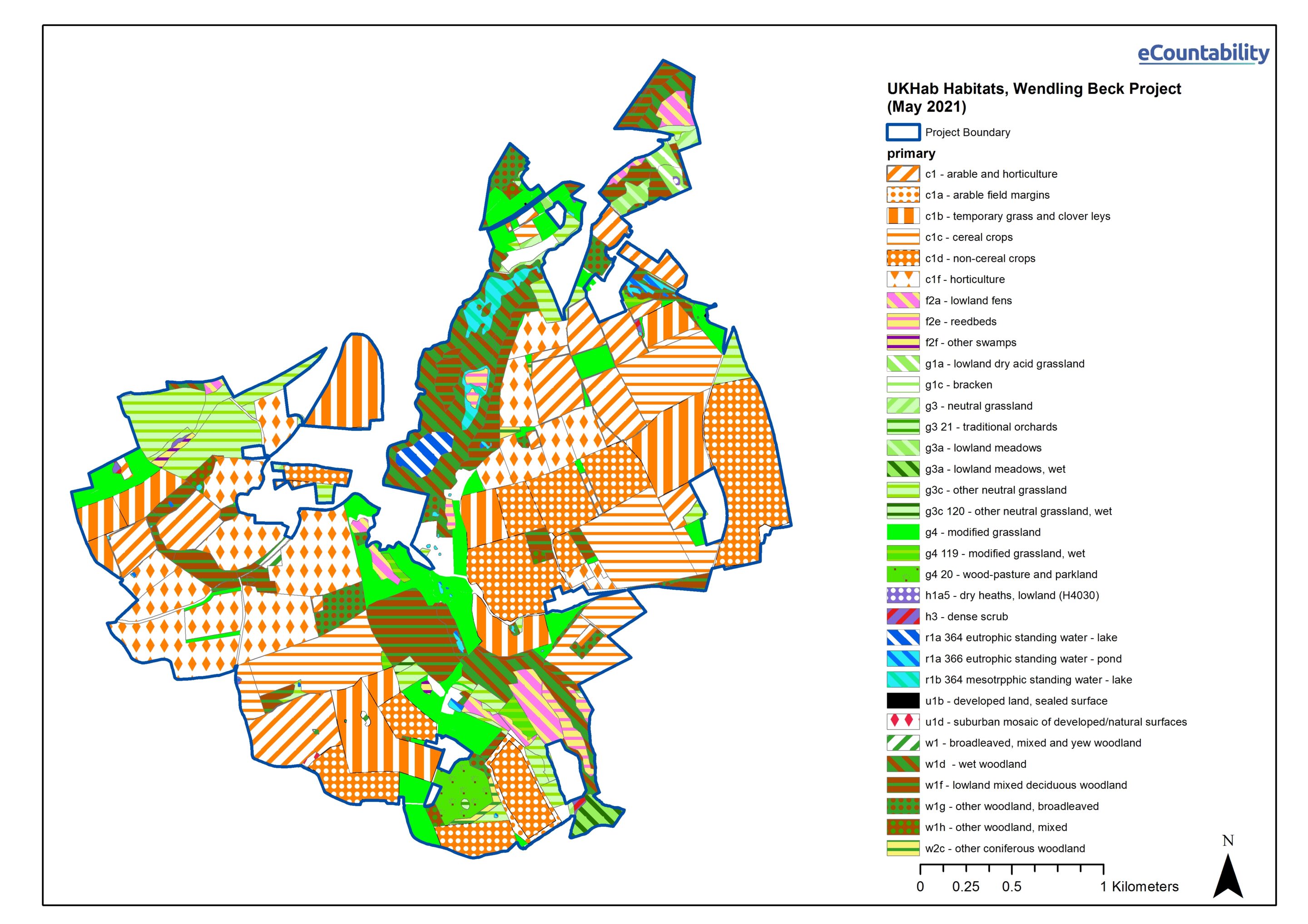
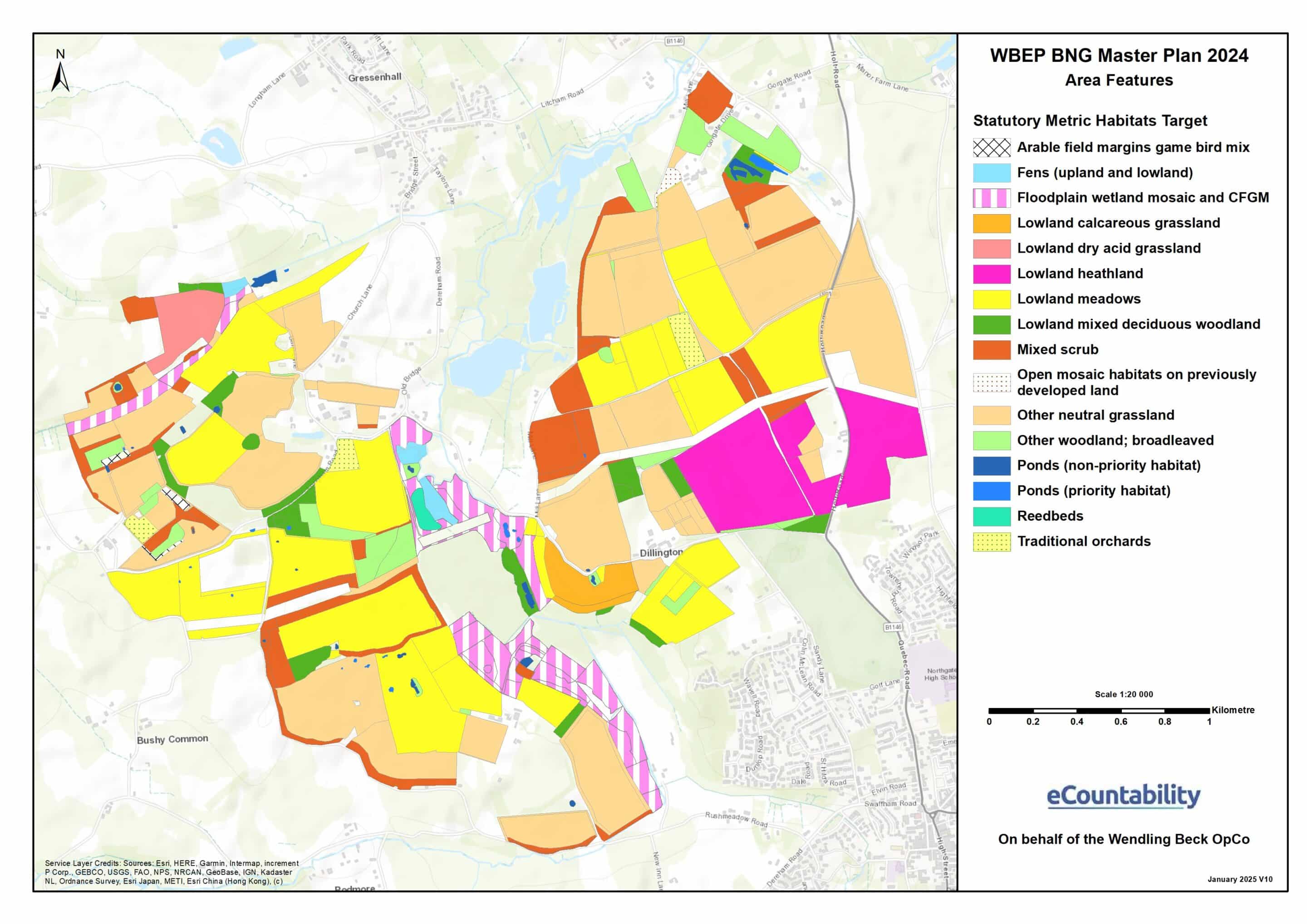
Figures 1 and 2: UKHab Habitat Maps and Area Features of WBP
Anderson also highlights that timing is important. “Between May and September is best for baselining biodiversity and above ground carbon, as out of season data can be fairly useless. You must also do the baselining before spades go in the ground, so that you are capturing the full uplift.”
The following ecosystem services with nature market potential were baselined:
- Biodiversity Net Gain (BNG)
In 2020, WBP was chosen as a pilot for Natural England’s Biodiversity Credits Scheme, trialling an early version of the statutory biodiversity metric.
WBP hired eCountability to baseline most of the Project’s land using the metric – with only the SSSI areas ineligible for BNG. Between four ecologists, this process took around three weeks of surveying, and a month of data processing. The baselining was concluded in May 2021. However, Anderson highlights that this process would likely be quicker now with firmer metric guidance and various technological improvements. Calculations for later metric versions were refreshed using the same baseline data.
Some ecological decisions were taken counter to the BNG metric’s incentives. For example, WBP has included wood pasture and parkland despite their low metric scoring. WBP has also used local provenance plant species and hand-collected most of its grass and flower seeds to increase the likelihood of habitat establishment and long-term resilience, despite the higher costs.
WBP is phasing its initial BNG habitat works. As of June 2025, around 50% of the Project area has commenced habitat establishment, with the creation of heath, scrub, species-rich meadow, wetland, watercourse and woodland habitats. WBP is projected to deliver ~3,000 biodiversity units across 35 habitat types (subject to the BNG metric’s temporal multiplier – see Milestone 5).
- Nutrient Neutrality
WBP aims to sell nutrient (phosphate and nitrate) credits to developers in the Wensum and Yare catchments of Norfolk, based on reversion of arable land and septic tank replacements.
WBP started working with ecological consultant Nutrient Neutral in March 2023 to help tackle the lack of local supply of nutrient credits and confusion over appropriate methodologies, following conversations with its Local Planning Authorities (LPAs) and Natural England.
Nutrient Neutral baselined the target sites using an early version of Natural England’s nutrient neutrality calculator and several datasets on land use, soil type, rainfall and other factors, followed by a period of ground surveying. It took 12 months to complete a technical mitigation strategy report , including WBP’s nutrient reduction calculations.
Many months of conversations followed between WBP, Natural England, Nutrient Neutral, the LPAs and legal advisors on the calculations and habitat plans. Anderson notes “when you consider nutrient neutrality on a landscape scale, there are dozens of permutations of this data that can lead to different outcomes… now that the methodologies have been approved, it should be easier for others to follow suit.” The total timescale to size WBP’s nutrient offering was about 18 months, and cost around £100K, including its legal agreements (see Milestone 8).
WBP plans to sell enough nutrient credits to release around 2,000 homes. Initial early revenue from the sale of nutrient credits is being used as capital investment to create habitats for longer term BNG (see Milestone 4).
- Carbon
WBP has been recording its above- and below-ground carbon stocks since 2021. As of June 2025, WBP does not plan to sell carbon credits, but should the market for BNG underperform, it could provide an alternative source of revenue. WBP also wishes to study its carbon levels to build its understanding of long-term landscape-scale change.
For above-ground carbon, WBP has worked with Treeconomy to quantify the carbon stored using hi-tech drone scanning and canopy height models. Anderson explained “We think there are gaps in the Woodland Carbon Code at the moment that don’t accurately reflect the carbon being sequestered in the landscape, particularly in more marginal habitat types like shrub and scrub.”
For below-ground carbon, WBP does not plan to sell soil carbon credits unless it has a clearer route to market. However, it has worked with several partners to measure its soil carbon stores, including:
- Agricarbon to undertake a high resolution baseline to 1M depth,
- the University of East Anglia (UEA), which has taken over 8,000 soil samples,
- several other academic partners as part of the Land Use Net Zero (LUNZ) soil carbon research
- UKCEH, with a carbon-flux tower installed to measure carbon flux in one of WBP’s restoration area.
Despite not planning to sell its soil carbon, the WBP team believes this work will fill important data gaps in a much wider analysis of carbon behaviour in different soil types and management regimes.
- Natural Flood Management (NFM)
In 2021, WBP commissioned JBA Consulting to undertake a hydrological assessment, which identified a frequent flood risk of the nearby Water Recycling Centre owned by Anglian Water (the regional water company). It also found that proposed NFM interventions, including river meandering and floodplain restoration, could significantly reduce this flood risk by up to 80-90%, and benefit a nearby protected site.
JBA’s work was mostly desk-based, cost around £10k and took three months to complete. However, this was supported by a subsequent piece of work by Ricardo in 2023 that collected further data and ground surveying, which also cost £10k and took three months.
As of July 2025, negotiations are ongoing with Anglian Water to co-fund the delivery of these interventions. Anglian Water plans to commission further hydrological studies and Charles Rangeley Wilson has been appointed as the architect for the restoration design, alongside Norfolk Rivers Trust as a delivery partner.
Monitoring, Management and Data Collection
WBP has an overarching Habitat Management and Monitoring Plan (HMMP)[1] that sets out the habitat creation, monitoring and long-term management plans of WBP’s environmental masterplan.
The HMMP was designed by eCountability and landscape architects Digg + Co once initial BNG baselining was concluded. Norfolk Wildlife Trust and the landowners were also consulted for their insight. This 18-month process produced a 200-page HMMP, covering the estimated timings of different habitat delivery, appropriate management, and other ecological considerations, such as how to mitigate drought risk. Now that habitat works have commenced, a simplified user guide has been produced for week-to-week activity.
The HMMP incudes the legal monitoring and management requirements for the ecosystem services it has monetised. For example, BNG sites will receive a UKHab Survey and Metric Condition Assessment in Years 2, 5, 10, 20, 30, overseen by eCountability, with the results reported to the Responsible Body (RSK Biocensus).
Beyond these requirements, WBP wishes to capture data on species recovery, water quality, groundwater recharge, carbon storage and management technique effectiveness. Anderson says that this approach will:
- Give the Project a better understanding of the landscape’s change and the most effective types of interventions and management techniques,
- potentially inform future environmental policy, through WBP’s connections with Government,
- potentially allow access to future nature-linked revenue streams, or improve WBP’s standing with its current buyer base.
For data collection, WBP has formed working relationships with several research partners, including the University of East Anglia (UEA), UK Centre for Hydrology and Ecology (UKCEH), Cambridge University, Water Resources East, Wilder Sensing, WATR, eCountability, UK Hab, LandApp, Viridian Logic, SOYL, Parklife Monitoring, ACE Nature, ADAS and the Earlham Institute. Some of this work has been costed on a low-bono basis, or has been resourced through time in kind. However, much of this work has been paid for by philanthropic and government grants, or WBP’s own investment.
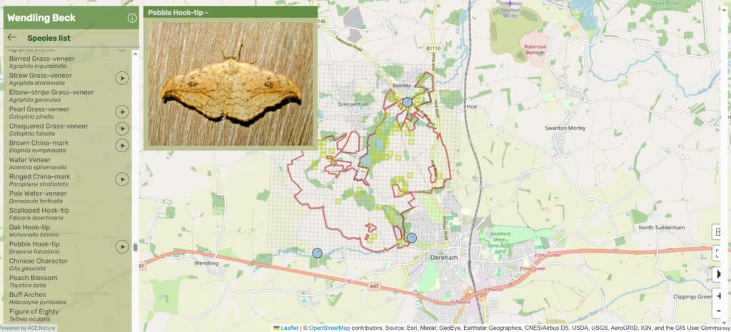
Figure 3: Wendling Beck Project’s WildMap
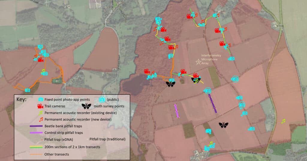
Methods used to gather environmental data include:
- Traditional ground-based (UKHab) surveys
- Trail cameras and fixed point photography
- Pitfall traps
- Moth trapping
- High resolution remote sensing (satellite + AI)
- Bioacoustic monitoring
- Environmental DNA (for water and soils)
- Real-time water quality monitoring
- Carbon flux monitoring
- People counters
- Bioblitz events
WBP also records its own management interventions and techniques, such seed mix data, sowing dates and density/depth, sometimes using control sites to compare effectiveness.
While advances in technology have given the Project a significant amount of insight, Anderson stresses that some level of ‘ground truthing’ will always be necessary, and encourages a balance for all projects.
WBP has now accumulated a significant amount of data and has partnered with ACENature to develop a WildMap that can organise and streamline data access – with data points allocated on a 100m square grid. The WildMap can be accessed by different partners and is compatible with common GIS software. WBP plans to use this tool to help with its decision-making. WBP also plans to make its WildMap publicly available.
Figures 4: Wendling Beck Project’s WildMap – Species View
For further information on WBP’s ecological data management, the below resources are recommended:
[1] A Habitat Management and Monitoring Plan is now a standardised document that is legally required for all off-site BNG projects, but WBP has developed a more detailed version of this as part of its overall approach.


